
THE ARTERY LEADS TO A NETWORK THAT LINKS THREE VOIDS, LARGE ENOUGH TO RALLY TROOPS, HORSES AND CANNONS
(AMONG THE FIRST TRANSFORMATIONS, IN 1852-1853)
They are place Saint-Michel and the spaces in front of Notre-Dame Cathedral and City Hall:

Adapted from a Google map
# # #
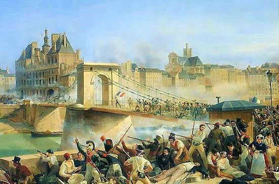
At the river soldiers crossed a new bridge to the left bank, where they regrouped at hugely enlarged place Saint-Michel:

"N:" originally pont [bridge] Napoleon III; after the Emperor's downfall, pont National

"Walls of Medieval Paris Discovered during Demolitions for Place Saint-Michel, engraving 1860 / zoom
 |
| Photo from the web, photographer unknown |
There they might stay to confront residents of the turbulent neighborhood, or take either the prolonged artery toward the working-class south or widened streets toward the parvis of Notre-Dame Cathedral:

Boulevard Saint-Michel
 |
| View from a tower of Notre-Dame |
At the end of the parvis they could take an enlarged street and a reinforced bridge to another greatly enlarged space, the esplanade in front of City Hall:


Model at the Musée Carnavalet

# # #
It became the heart of a second network, at the center of the right bank:

- To the left is the relatively straight trade route that had been enlarged for tournaments and was the route that Louis XIV had taken for his cortège made building an artery toward the working-class east unnecessary:

The trade route (rue Saint-Antoine), wide and straight enough for marching troops.
- To the right, as at Notre-Dame, an insignificant street lies alongside the expanse.

- It leads to another wide, straight street (avenue Victoria) from which the army could reach Châtelet, the center of the right bank, five minutes away:

# # #
Behind City Hall were the Lobau barracks. More later.
# # #
Of course such changes allowed a circulation that was infinitely more fluid and let in light and air.
But the three huge voids, two of which are dead ends,
have no tie with those objectives.
They were for assembling soldiers, horses and cannons.
* * *
Next,
No comments:
Post a Comment